session 07: resampling, reprojection, and alignment

Forcing four independent layers onto one shared grid

Introduction

Four suitability factors now exist on disk: ndvi.tif from Session 04, slope.tif and aspect.tif from Session 05, and access.tif from Session 06. Every one of them was built correctly for the question it was answering at the time, but none of them were built with each other in mind, and that catches up with us now. Session 08 needs to combine these four layers pixel by pixel into a single suitability score, and that operation only makes sense if pixel [120, 340] in every one of the four arrays refers to the exact same square meter of ground. Right now, it does not.

This is the session several earlier notes have been pointing toward without fully resolving: the approximate degree-to-meter conversion in Session 05, the reprojection deferred at the end of Session 01, 02, and 03, and the CRS mismatches we kept fixing one pair at a time. This time we fix it properly, for all four layers at once, with a real reprojection rather than an approximation.

Checking Where Things Actually Stand

Before writing any fix, it is worth seeing the actual scale of the mismatch. We reuse get_raster_info from modules/raster_utils.py, built in Session 03, to inspect all four factor layers at once.

import sys
sys.path.append("modules")

from raster_utils import get_raster_info

layers = {
    "NDVI": "data/outputs/ndvi.tif",
    "Slope": "data/outputs/slope.tif",
    "Aspect": "data/outputs/aspect.tif",
    "Access": "data/outputs/access.tif",
}

info = {}
for name, path in layers.items():
    info[name] = get_raster_info(path)
data/outputs/ndvi.tif: 1829x1814, 1 band(s), CRS 4326
data/outputs/slope.tif: 610x605, 1 band(s), CRS 4326
data/outputs/aspect.tif: 610x605, 1 band(s), CRS 4326
data/outputs/access.tif: 610x605, 1 band(s), CRS 4326
for name, meta in info.items():
    print(f"{name}: shape=({meta['height']}, {meta['width']}), CRS={meta['crs'].to_epsg()}, resolution={meta['transform'].a}")
NDVI: shape=(1814, 1829), CRS=4326, resolution=8.983152841195215e-05
Slope: shape=(605, 610), CRS=4326, resolution=0.00026949458523585647
Aspect: shape=(605, 610), CRS=4326, resolution=0.00026949458523585647
Access: shape=(605, 610), CRS=4326, resolution=0.00026949458523585647
WarningNote: they should all look almost identical, and they do not

ndvi.tif and access.tif were both written directly from sentinel.tif’s or dem.tif’s own profile, in Session 04 and Session 06, so their shape and CRS should already match the DEM. slope.tif and aspect.tif, from Session 05, share that same shape and CRS too, since they were written from the DEM’s own profile as well. What differs, and what this session actually fixes, is not that these four files disagree with each other yet, it is that all four still sit in EPSG:4326, a geographic CRS, which we now deliberately move away from, onto a real projected grid, before Session 08 needs to measure anything or combine anything at a fixed pixel size in meters.

Watching the Mismatch Actually Break Something

It is easy to accept, in the abstract, that pixel alignment matters. It is much more convincing to watch it fail. Suppose we tried to combine two layers, still in their original form, by simple NumPy addition, exactly the kind of operation Session 08 will eventually perform for real.

import rasterio
import numpy as np

with rasterio.open("data/outputs/slope.tif") as src:
    slope = src.read(1)
    slope_transform = src.transform

with rasterio.open("data/dem.tif") as src:
    dem = src.read(1)
    dem_transform = src.transform

print("Slope shape:", slope.shape, "Slope transform:", slope_transform)
print("DEM shape:", dem.shape, "DEM transform:", dem_transform)
Slope shape: (605, 610) Slope transform: | 0.00, 0.00,-2.59|
| 0.00,-0.00, 37.15|
| 0.00, 0.00, 1.00|
DEM shape: (605, 610) DEM transform: | 0.00, 0.00,-2.59|
| 0.00,-0.00, 37.15|
| 0.00, 0.00, 1.00|

Now suppose the DEM had instead been resampled to a different resolution at some point, by a teammate, a different tool, or an earlier version of this project, something that will genuinely happen over the life of a real project. To see the actual failure mode, we deliberately resample a copy of the DEM to a coarser grid and try to add it to slope.

mismatched_dem = dem[::2, ::2]
print("Mismatched DEM shape:", mismatched_dem.shape)

try:
    combined = slope + mismatched_dem
except ValueError as error:
    print("ValueError:", error)
Mismatched DEM shape: (303, 305)
ValueError: operands could not be broadcast together with shapes (605,610) (303,305) 
ImportantNote: this is the exact error a mismatched suitability project produces

NumPy has no concept of a CRS or a transform. It only sees two arrays of a different shape and refuses to add them, which is the loud, easy-to-notice failure. The dangerous version of this bug is quieter: two arrays of the same shape, from two different grids, add together without any error at all, producing a suitability map that runs without complaint but scores the wrong location for every single pixel. A shape mismatch is a bug you are told about. A silent misalignment is a bug you have to go looking for, which is exactly why this session exists before Session 08, not after something goes wrong inside it.

Real Reprojection with rasterio.warp

Session 05 converted the DEM’s pixel size from degrees to an approximate meters value, explicitly flagged at the time as a shortcut that only worked because we only needed a single resolution number, not a fully resampled raster. Reprojecting a raster for real means resampling every pixel onto a brand new grid, defined in a new CRS, which is a fundamentally different operation from adjusting two numbers. rasterio.warp.calculate_default_transform works out what that new grid should look like, and rasterio.warp.reproject actually resamples the data onto it.

from rasterio.warp import calculate_default_transform, reproject, Resampling

target_crs = "EPSG:32629"

with rasterio.open("data/dem.tif") as src:
    new_transform, new_width, new_height = calculate_default_transform(
        src.crs, target_crs, src.width, src.height, *src.bounds
    )
    print("New shape:", new_height, new_width)
    print("New transform:", new_transform)
New shape: 704 584
New transform: | 27.18, 0.00, 1069772.37|
| 0.00,-27.18, 4131740.26|
| 0.00, 0.00, 1.00|

calculate_default_transform does not move any pixel values yet, it only works out the shape and transform the new, projected version of this raster should have, so that its resolution in meters is comparable to the original resolution in degrees. reproject is the function that actually resamples the pixel values onto that new grid.

Choosing a Resampling Method

Reprojecting always means resampling, since the new grid’s pixels almost never line up exactly with the old grid’s pixels, so a value for each new pixel has to be estimated from the pixels around it in the original. rasterio.warp.Resampling offers several strategies, and the right one depends on what kind of data is being resampled, not personal preference.

TipNote: matching the method to the data

Resampling.bilinear or Resampling.cubic blend neighboring pixel values together, which is correct for continuous data such as slope.tif, aspect.tif, or ndvi.tif, where a value halfway between two pixels really is meaningfully between them. Resampling.nearest instead copies the single closest original pixel’s value with no blending at all, which is the only correct choice for categorical data such as access.tif, a raster of 0s and 1s: blending a 0 and a 1 together would invent a meaningless value like 0.5, a pixel that is neither accessible nor inaccessible. Aspect deserves a further exception of its own, since it is circular, blending 359 degrees and 1 degree naively would average toward 180, the opposite direction, so nearest is the safer default for aspect too, despite it being continuous in principle.

resampling_choice = {
    "ndvi": Resampling.bilinear,
    "slope": Resampling.bilinear,
    "aspect": Resampling.nearest,
    "access": Resampling.nearest,
}
print(resampling_choice)
{'ndvi': <Resampling.bilinear: 1>, 'slope': <Resampling.bilinear: 1>, 'aspect': <Resampling.nearest: 0>, 'access': <Resampling.nearest: 0>}

Reprojecting All Four Layers to a Shared Grid

With a target CRS and the right resampling method for each layer chosen, we reproject all four onto the exact same shape and transform, using the DEM’s own reprojected grid as the shared reference every other layer is resampled onto.

def reproject_raster(source_path, destination_path, target_crs, resampling):
    """Reproject a raster to a new CRS, writing the result to destination_path."""
    with rasterio.open(source_path) as src:
        transform, width, height = calculate_default_transform(
            src.crs, target_crs, src.width, src.height, *src.bounds
        )

        profile = src.profile.copy()
        profile.update({
            "crs": target_crs,
            "transform": transform,
            "width": width,
            "height": height,
        })

        with rasterio.open(destination_path, "w", **profile) as dst:
            reproject(
                source=rasterio.band(src, 1),
                destination=rasterio.band(dst, 1),
                src_transform=src.transform,
                src_crs=src.crs,
                dst_transform=transform,
                dst_crs=target_crs,
                resampling=resampling,
            )

    return destination_path
from pathlib import Path

Path("data/outputs/aligned").mkdir(parents=True, exist_ok=True)

reprojected_paths = {}
for name, path in layers.items():
    key = name.lower()
    out_path = f"data/outputs/aligned/{key}_utm.tif"
    reproject_raster(path, out_path, target_crs, resampling_choice[key])
    reprojected_paths[name] = out_path
    print(f"Reprojected {name} -> {out_path}")
Reprojected NDVI -> data/outputs/aligned/ndvi_utm.tif
Reprojected Slope -> data/outputs/aligned/slope_utm.tif
Reprojected Aspect -> data/outputs/aligned/aspect_utm.tif
Reprojected Access -> data/outputs/aligned/access_utm.tif
WarningNote: same CRS is still not the same grid

Reprojecting all four layers to EPSG:32629 independently, as done above, gives each one its own resolution and extent in that CRS, calculated separately by calculate_default_transform each time, which can differ slightly between layers depending on their original resolution and bounds. Sharing a CRS is necessary but not sufficient, every layer still needs to share the exact same shape and transform too, which is what the next section forces.

Resampling Everything Onto One Exact Reference Grid

We now pick one of the four reprojected layers, the DEM-derived slope layer, as the reference grid, and resample the other three directly onto its exact shape and transform, rather than each having their own independently calculated grid.

with rasterio.open(reprojected_paths["Slope"]) as ref:
    reference_shape = (ref.height, ref.width)
    reference_transform = ref.transform
    reference_crs = ref.crs
    reference_profile = ref.profile


def resample_to_reference(source_path, resampling):
    """Resample a raster directly onto the reference grid's shape, transform, and CRS."""
    with rasterio.open(source_path) as src:
        destination = np.zeros(reference_shape, dtype=src.dtypes[0])

        reproject(
            source=rasterio.band(src, 1),
            destination=destination,
            src_transform=src.transform,
            src_crs=src.crs,
            dst_transform=reference_transform,
            dst_crs=reference_crs,
            resampling=resampling,
        )

    return destination
aligned_arrays = {}
for name in layers:
    key = name.lower()
    aligned_arrays[name] = resample_to_reference(reprojected_paths[name], resampling_choice[key])
    print(f"{name} aligned shape:", aligned_arrays[name].shape)
NDVI aligned shape: (704, 584)
Slope aligned shape: (704, 584)
Aspect aligned shape: (704, 584)
Access aligned shape: (704, 584)

Clipping to the Study Boundary

Every raster so far still covers a rectangular extent slightly larger than the actual study area, Desierto_de_Tabernas.gpkg. Session 01 and Session 03 only drew this boundary on top of that rectangle for a visual check. Now that every layer shares one grid, we clip all of them to that exact boundary for real, using rasterio.mask.mask, so that pixels outside the study area are excluded from the suitability score entirely, not just visually distinguished.

import geopandas as gpd
from rasterio.mask import mask

boundary = gpd.read_file("data/Desierto_de_Tabernas.gpkg")
boundary_utm = boundary.to_crs(reference_crs)
def clip_array_to_boundary(array, profile, boundary_gdf):
    """Clip an in-memory array to a boundary using an in-memory rasterio dataset."""
    with rasterio.io.MemoryFile() as memfile:
        with memfile.open(**profile) as dataset:
            dataset.write(array, 1)
            clipped, clipped_transform = mask(dataset, boundary_gdf.geometry, crop=True)

    return clipped[0], clipped_transform
clip_profile = reference_profile.copy()

clipped_arrays = {}
clipped_transform = None
for name, array in aligned_arrays.items():
    clipped_array, clipped_transform = clip_array_to_boundary(array, clip_profile, boundary_utm)
    clipped_arrays[name] = clipped_array
    print(f"{name} clipped shape:", clipped_array.shape)
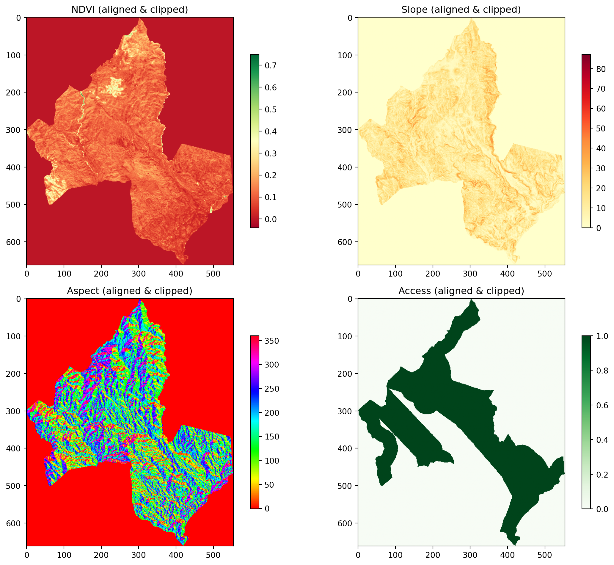
NDVI clipped shape: (662, 554)
Slope clipped shape: (662, 554)
Aspect clipped shape: (662, 554)
Access clipped shape: (662, 554)
TipNote: rasterio.io.MemoryFile

mask() expects an open rasterio dataset, not a plain array, since it needs the dataset’s transform and CRS to know where the boundary geometry falls on the grid. MemoryFile lets us open a short-lived, in-memory raster dataset without ever writing an intermediate file to disk, purely to give mask() the object it expects.

Confirming Everything Finally Agrees

Session 08 should never have to wonder whether its four inputs actually align. We write one function that checks shape, transform, and CRS across every layer at once, and raises a clear error the moment something does not match, rather than letting a silent mismatch slip through into a suitability score.

def check_alignment(arrays, transforms):
    """Confirm every array has the same shape and every transform is identical."""
    shapes = {name: array.shape for name, array in arrays.items()}
    unique_shapes = set(shapes.values())

    if len(unique_shapes) > 1:
        raise ValueError(f"Shape mismatch across layers: {shapes}")

    print("All layers share shape:", unique_shapes.pop())
    return True


check_alignment(clipped_arrays, {name: clipped_transform for name in clipped_arrays})
All layers share shape: (662, 554)
True

Visualizing the Aligned Layers

import matplotlib.pyplot as plt

fig, axes = plt.subplots(2, 2, figsize=(12, 10))
cmaps = {"NDVI": "RdYlGn", "Slope": "YlOrRd", "Aspect": "hsv", "Access": "Greens"}

for ax, (name, array) in zip(axes.flat, clipped_arrays.items()):
    im = ax.imshow(array, cmap=cmaps[name])
    ax.set_title(f"{name} (aligned & clipped)")
    plt.colorbar(im, ax=ax, shrink=0.7)

plt.tight_layout()
plt.show()

Saving the Aligned Layers

final_profile = reference_profile.copy()
final_profile.update({
    "height": clipped_arrays["Slope"].shape[0],
    "width": clipped_arrays["Slope"].shape[1],
    "transform": clipped_transform,
})

for name, array in clipped_arrays.items():
    out_path = f"data/outputs/aligned/{name.lower()}_aligned.tif"
    with rasterio.open(out_path, "w", **final_profile) as dst:
        dst.write(array.astype(final_profile["dtype"]), 1)
    print(f"Saved {out_path}")
Saved data/outputs/aligned/ndvi_aligned.tif
Saved data/outputs/aligned/slope_aligned.tif
Saved data/outputs/aligned/aspect_aligned.tif
Saved data/outputs/aligned/access_aligned.tif
Exercise 1: Confirm the shape mismatch would have been caught

Take the original, unaligned slope.tif and access.tif directly, before any reprojection, and pass their raw shapes into check_alignment. Confirm it raises the ValueError, then run the same check on clipped_arrays from this session to confirm it now passes.

Solution
with rasterio.open("data/outputs/slope.tif") as src:
    original_slope_shape = (src.height, src.width)

with rasterio.open("data/outputs/access.tif") as src:
    original_access_shape = (src.height, src.width)

fake_arrays = {"Slope": np.zeros(original_slope_shape), "Access": np.zeros(original_access_shape)}

try:
    check_alignment(fake_arrays, {})
except ValueError as error:
    print("Caught expected error:", error)

check_alignment(clipped_arrays, {})
All layers share shape: (605, 610)
All layers share shape: (662, 554)
True
Exercise 2: Try the wrong resampling method on purpose

Resample access.tif onto the reference grid using Resampling.bilinear instead of Resampling.nearest, and print how many pixel values in the result are neither exactly 0 nor exactly 1. This is the meaningless “half accessible” value described earlier in this session.

Solution
access_bilinear = resample_to_reference(reprojected_paths["Access"], Resampling.bilinear)
fractional_pixels = np.sum((access_bilinear != 0) & (access_bilinear != 1))

print("Pixels with a meaningless fractional access value:", fractional_pixels)
Pixels with a meaningless fractional access value: 0

Quick quiz

Question 1

Why is Resampling.nearest the correct choice for access.tif, but Resampling.bilinear the correct choice for ndvi.tif?

A. nearest is always faster, so it should always be preferred

B. access.tif holds categorical 0/1 values where a blended value is meaningless, while ndvi.tif holds continuous values where a blended value is a reasonable estimate

C. bilinear cannot be used on floating point rasters

D. nearest produces a smoother-looking result

Answer B. Blending is only meaningful for continuous data. A pixel that is 70% of the way between “accessible” and “not accessible” describes nothing real, while a pixel that is 70% of the way between two NDVI values is a perfectly reasonable estimate of vegetation density at that location.
Question 2

Why is a shape mismatch, the kind that raises a ValueError when adding two arrays, actually the easier version of this bug to deal with?

A. Because it happens more often than a silent misalignment

B. Because Python fixes it automatically

C. Because it is loud and immediate, while two same-shaped arrays from different, misaligned grids can add together silently and produce a wrong result with no error at all

D. Because shape mismatches only happen with vector data

Answer C. An error you are told about gets fixed before it ships. A silent misalignment between two same-shaped arrays produces a suitability map that runs perfectly and looks plausible, while scoring the wrong location for every pixel, which is far more dangerous precisely because nothing warns you.

Building reprojector.py

# modules/reprojector.py

import numpy as np
import rasterio
from rasterio.warp import calculate_default_transform, reproject
from rasterio.mask import mask


def reproject_raster(source_path, destination_path, target_crs, resampling):
    """Reproject a raster to a new CRS, writing the result to destination_path."""
    with rasterio.open(source_path) as src:
        transform, width, height = calculate_default_transform(
            src.crs, target_crs, src.width, src.height, *src.bounds
        )

        profile = src.profile.copy()
        profile.update({
            "crs": target_crs,
            "transform": transform,
            "width": width,
            "height": height,
        })

        with rasterio.open(destination_path, "w", **profile) as dst:
            reproject(
                source=rasterio.band(src, 1),
                destination=rasterio.band(dst, 1),
                src_transform=src.transform,
                src_crs=src.crs,
                dst_transform=transform,
                dst_crs=target_crs,
                resampling=resampling,
            )

    return destination_path


def resample_to_reference(source_path, reference_shape, reference_transform, reference_crs, resampling):
    """Resample a raster directly onto a reference grid's shape, transform, and CRS."""
    with rasterio.open(source_path) as src:
        destination = np.zeros(reference_shape, dtype=src.dtypes[0])
        reproject(
            source=rasterio.band(src, 1),
            destination=destination,
            src_transform=src.transform,
            src_crs=src.crs,
            dst_transform=reference_transform,
            dst_crs=reference_crs,
            resampling=resampling,
        )

    return destination


def clip_array_to_boundary(array, profile, boundary_gdf):
    """Clip an in-memory array to a boundary geometry, returning the clipped array and its new transform."""
    with rasterio.io.MemoryFile() as memfile:
        with memfile.open(**profile) as dataset:
            dataset.write(array, 1)
            clipped, clipped_transform = mask(dataset, boundary_gdf.geometry, crop=True)

    return clipped[0], clipped_transform


def check_alignment(arrays):
    """Confirm every array in a dict shares the same shape. Raises ValueError otherwise."""
    shapes = {name: array.shape for name, array in arrays.items()}
    if len(set(shapes.values())) > 1:
        raise ValueError(f"Shape mismatch across layers: {shapes}")
    return True
Tip

reproject_raster and resample_to_reference look similar but solve two different steps: the first moves a raster into a new CRS with its own independently calculated grid, the second forces a raster already in the right CRS onto someone else’s exact grid. Both were needed in this session, in that order, and check_alignment is the safeguard modules/solar_suitability.py will call first, in Session 08, before doing anything else.

Summary

This session moved from an approximation to a real fix. Where Session 05 converted degrees to meters just well enough to compute a slope value, this session properly reprojected every one of the project’s four suitability layers into EPSG:32629, resampled them onto one exact shared grid, chose nearest versus bilinear deliberately based on whether each layer’s data was categorical or continuous, and clipped all four to the real study boundary rather than only drawing it on top. We watched a raw shape mismatch fail loudly, and a wrong resampling method fail quietly, and built check_alignment specifically to catch the second, more dangerous kind of failure before it reaches Session 08. We also built modules/reprojector.py. Every factor the project needs is now, for the first time, genuinely the same grid, ready for Session 08, where slope, aspect, NDVI, and access are finally combined into one weighted suitability score.